Daly Street, September 2025
Proposed parking restrictions on Daly Street, Kurralta Park
Open for feedback 3 September - 24 September 2025.
During the 2025/26 financial year Council is reconstructing Daly Street between Mortimer Terrace and Cross Terrace. This includes reconstruction of the kerbing both sides of the street, resurfacing with new asphalt, and the construction of new raised plateau speed humps.
Road upgrade
The raised plateau speed humps are part of broader Local Area Traffic Management works for the locality, with plateau humps proposed in Daly Street (4 humps) and Gray Street (5 humps) that were endorsed by Council at the meeting 1 October 2024.
The current width of Daly Street (approximately 8.8 metres wide) means when vehicles are parked both sides of the street there is insufficient width for two opposing vehicles to pass at the same time, however the gap between the parked cars can be misjudged and interpreted as being wide enough causing confusion, congestion, and accidents.
In the past 4 years there have been 4 crashes between vehicles and parked cars.
We recognise that with urban infill the demand for on street parking is always increasing, and this demand must be balanced against the need to provide a safe environment for road users.
To address this safety risk during the reconstruction of the kerbing and asphalt the width of the road will be modified to be consistent with Gray Street and be 8.2 metres wide.
This would permit parking both sides of the street and make it clear that the centre lane for through traffic is only wide enough for one vehicle at a time. As with the current road width, when two vehicles are coming in opposite directions one would have to give way behind parked cars or at driveways until the road is clear.
While the change in road width will make a safer road environment for vehicles, it does not address the congestion in Daly Street and the delays experienced by waiting for opposing vehicles to pass for the road to be clear. An option for this to be resolved is through limiting on street parking to enable two-way movements, but this comes at the expense of parking spaces.
Options for car parking
Three car parking options have been developed for Daly Street, and community feedback will be considered in selecting one option to go ahead with.
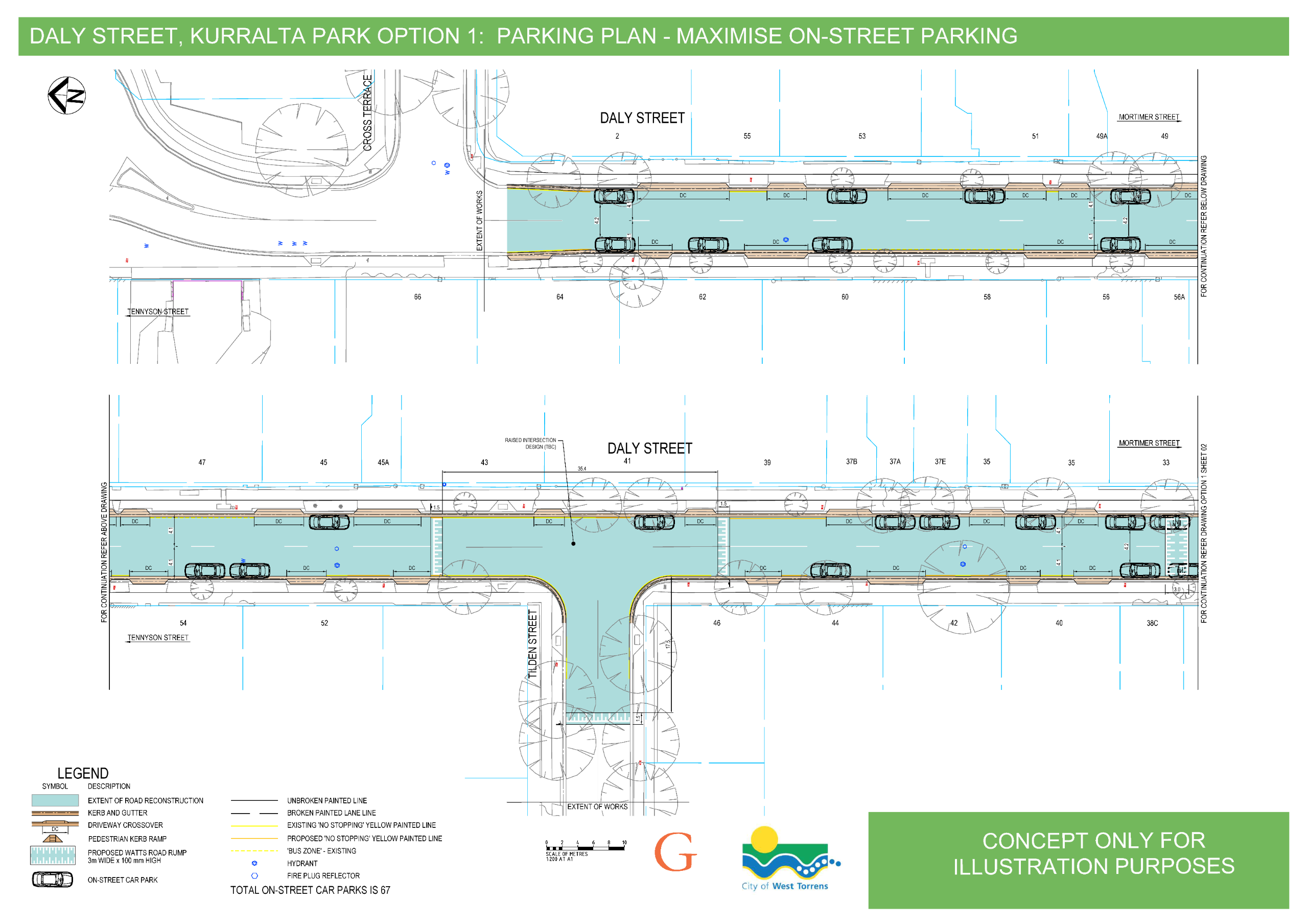
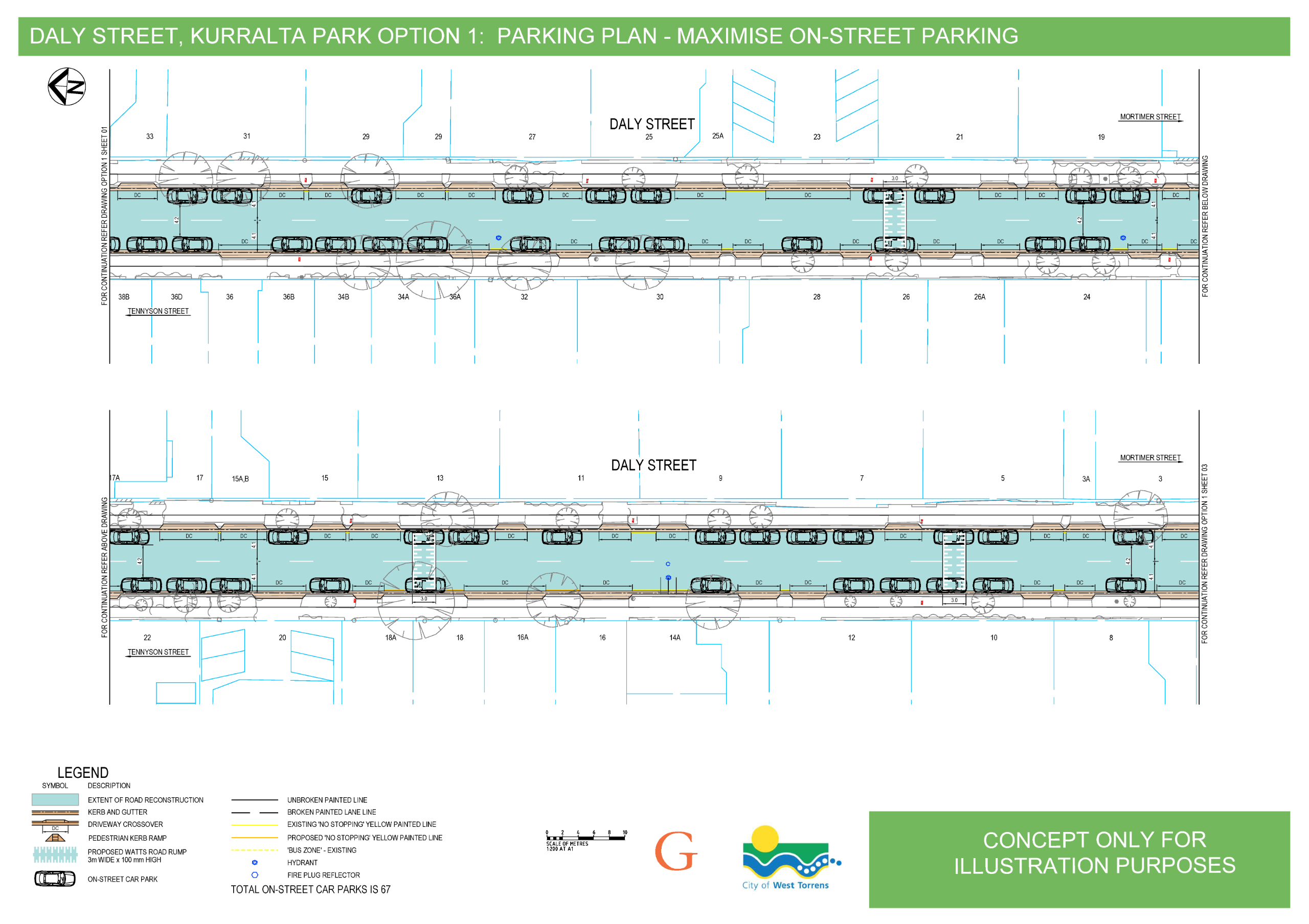
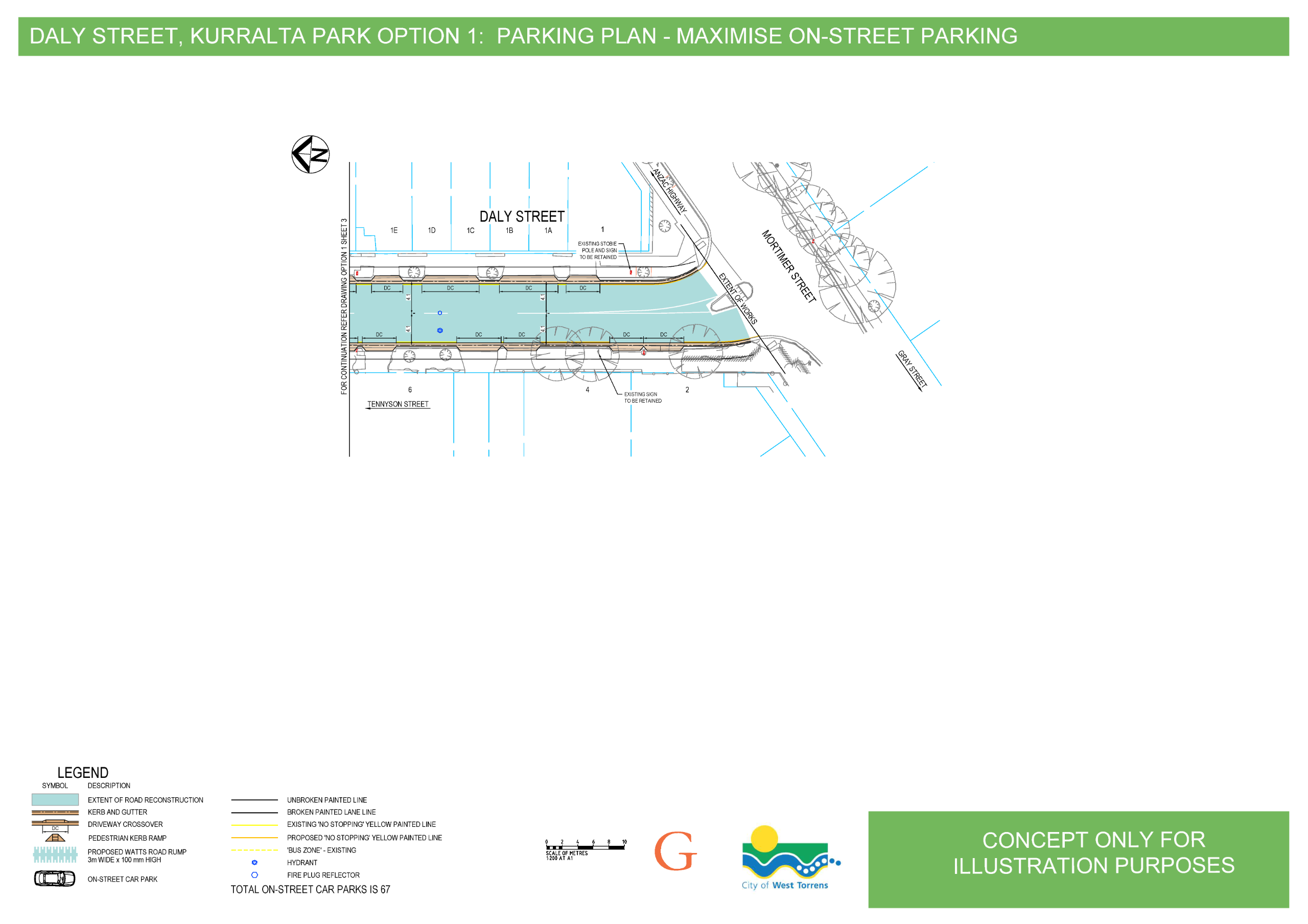
Option 1: Maximise on street parking (the current status quo for Daly St)
- Retain current on street parking on both sides of the street.
- With the new road width, one vehicle can pass through the central gap and vehicles travelling in the opposite direction will give way by waiting at driveways or in vacant spaces.
- Retain the current 67 on street car parks with no changes.
View the plans below or download a pdf.
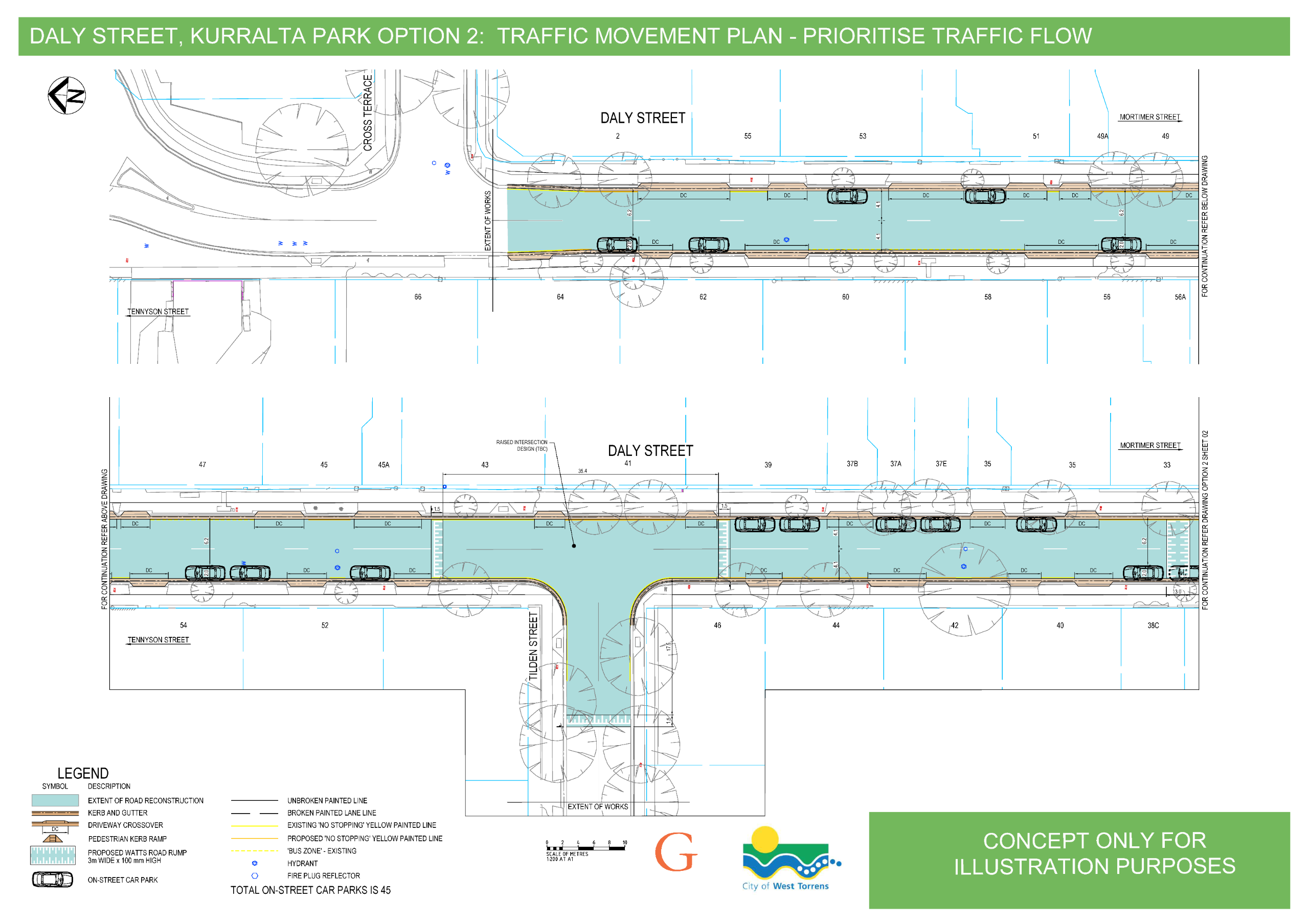
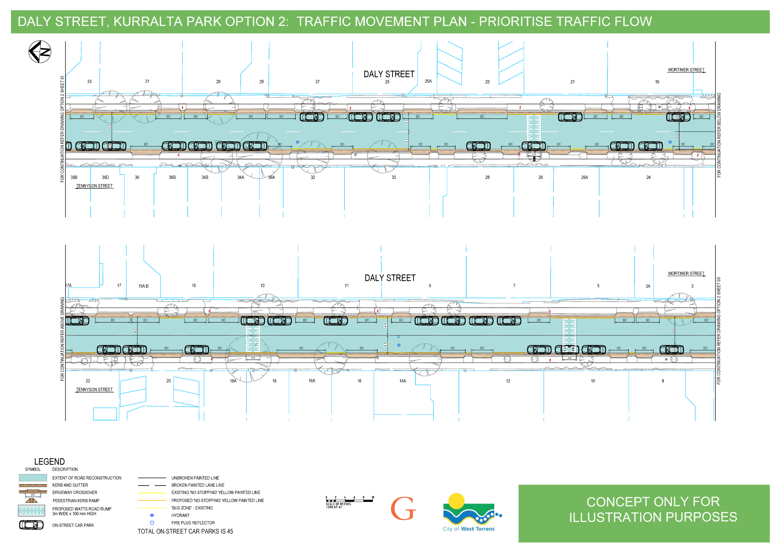
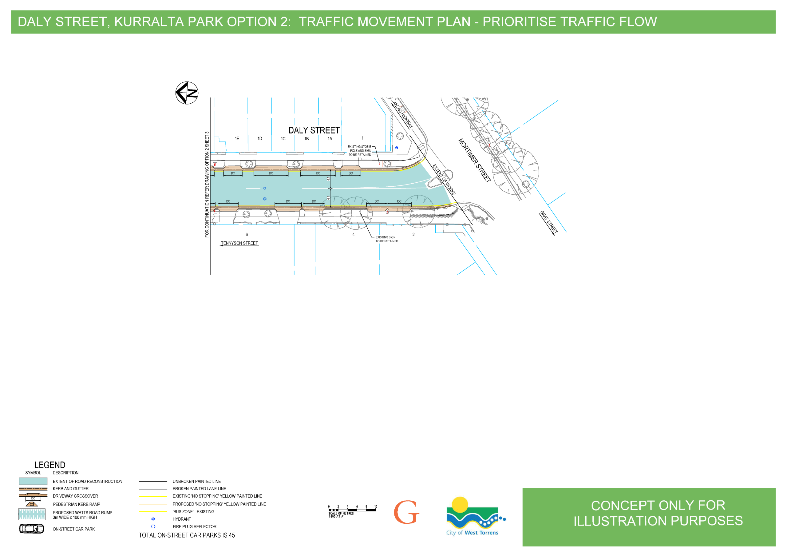
Option 2: Maximise traffic flow
- Create 'no parking' zones staggered along the length of the street.
- Two-way traffic flow will be possible at all times.
- Reduce on street car parks from 67 to 45 (a reduction of 22 spaces from current number).
View the plans below or download a pdf.
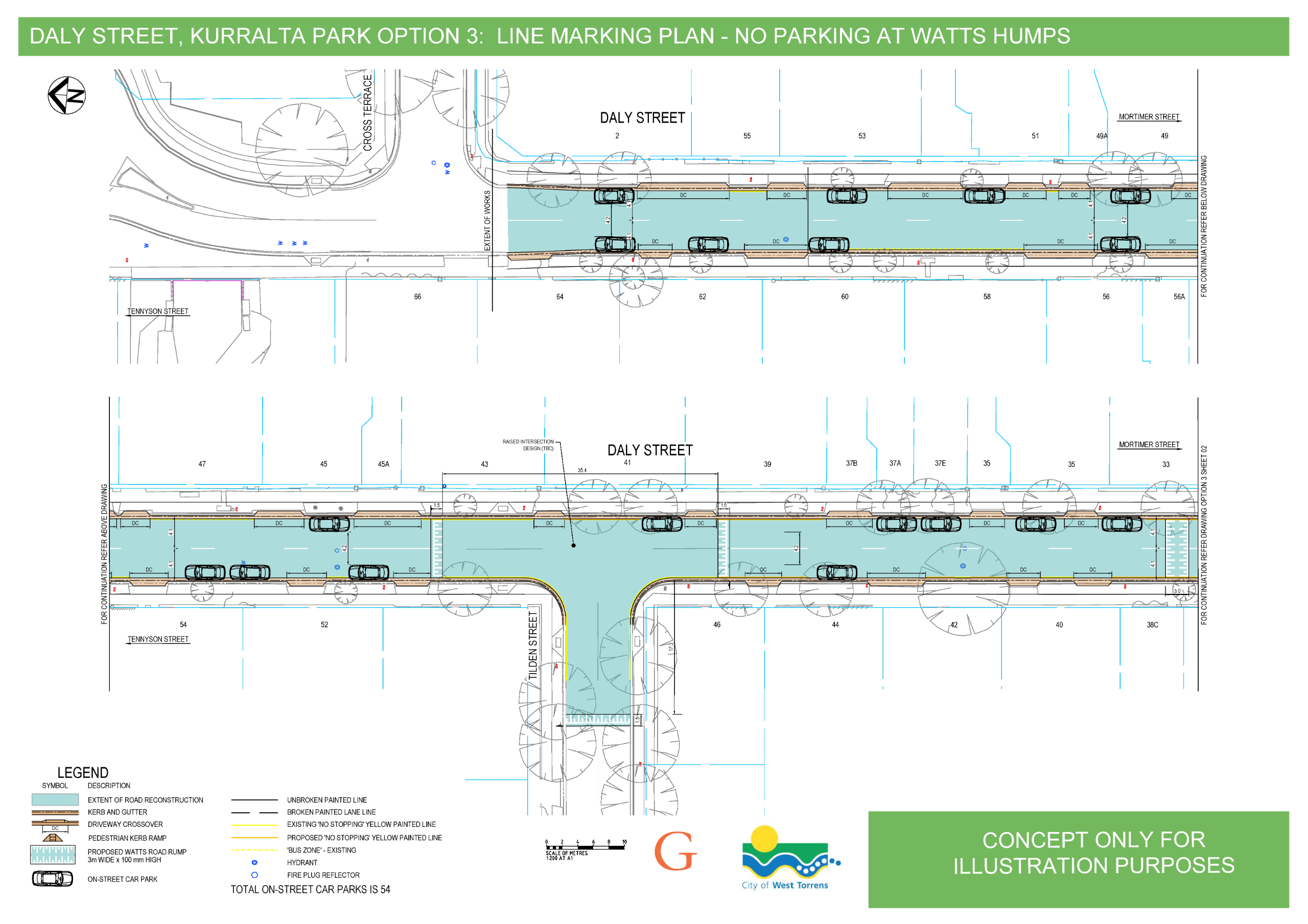
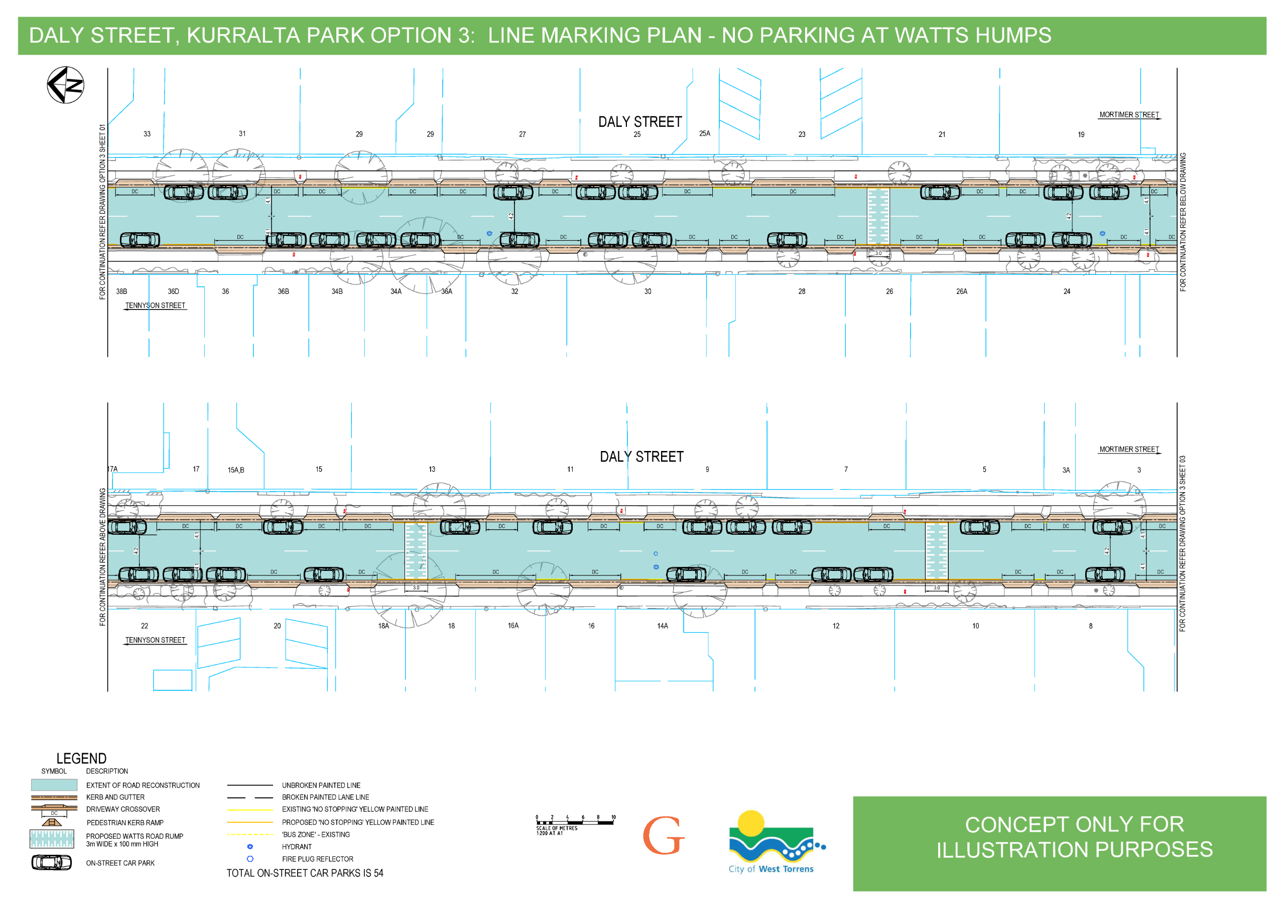
Option 3: Balance on street parking and traffic flow
- Create 'no parking' zones at the raised plateau speed humps only.
- With new road width:
- for the majority of the road length one vehicle can pass through the central gap and vehicles travelling in the opposite direction will give way, and
- additional opportunities for two-way traffic flow will be created where raised speed humps are in place and vehicles are slowing their approach.
- Reduce on street car parks from 67 to 54 (a reduction of 13 spaces from current number).
View the plans below or download a pdf.

Proposed parking restrictions on Daly Street, Kurralta Park
Update - 1 August 2025
This consultation was opened on 27 July and scheduled to close on 15 August 2025. This consultation is currently on hold and will be reopened at a later date. Contributions made between 27 July and 1 August have been recorded.
For further information, contact the City of West Torrens on 8416 6333 orinfo@wtcc.sa.gov.au.
Bagot Avenue, May2025
Proposed traffic management control on Bagot Avenue, Mile End
Update - 7 August 2025
Between 14 April and 9 May 2025 Council sought feedback from local residents on a proposal to address traffic congestion on Bagot Avenue, Mile End.
A report including a summary of feedback received was prepared for Council's Committee meeting of 5 August 2025. At this meeting it was resolved to defer consideration of proposed traffic management controls on Bagot Avenue to allow further investigation of alternative solutions to redirect traffic flows in the area.
Details of the Committee meeting including the Agenda, Minutes and audio recording can be found on Council's website, noting that the Minutes and audio recording will be available after 5pm on Friday 8 August 2025.
For further information, contact the City of West Torrens on 8416 6333 or info@wtcc.sa.gov.au.Open for feedback Monday 14 April - Friday 9 May 2025
Council is seeking feedback from local residents on a proposal to address traffic congestion on Bagot Avenue, Mile End. Consultation on this proposal is part of Council's approved Local Area Traffic Management Plan (LATM) for the area.
Traffic counts undertaken in late 2024 have identified a substantial increase in traffic along Bagot Avenue since 2019, significantly more than is experienced on surrounding streets.
The traffic control proposal has 2 parts that together will reduce traffic congestion and long queues on Bagot Avenue during peak periods:
- No Right Turn restriction for vehicles exiting Bagot Avenue to Henley Beach Road, between 7.30am and 9.00am, and 4.00pm and 6.00pm, Monday to Friday, AND
- Half road closure on Bagot Avenue, south of Norma Street. The half road closure will prevent traffic from Henley Beach Road continuing along Bagot Avenue south of Norma Street.
Proposed traffic control on Bagot Avenue:

Railway Terrace and Junction Lane, July 2024
Changes to temporary road closure arrangements at Railway Terrace and Junction Lane, Mile End, open for feedback between Wednesday 26 June and Friday 19 July 2024.
In early February 2024 Council notified adjacent residents and ratepayers of a temporary road closure to support construction of a major residential development on the corner of Junction Lane and Railway Terrace, Mile End.
Since that time (and following commencement of construction works), Council has received feedback from several local residents and businesses in relation to the development, which included concerns related to parking and access. Council Administration have listened and responded to these concerns, in collaboration with the builder of the development, to improve and address the queries and concerns made.
As a result, a number of changes have been proposed to the temporary road closure and the builder's use of the land. The elements of the arrangements around these works which have been modified and changed in response to resident, business, and community feedback are as follows:
- Decrease of the 'area which the Builder has been granted use over' to remove the land containing the protected temporary pedestrian detour past the development compound (connecting Hughes Street to Henley Beach Road). This will enable greater Council control over the management of this space, with the builder still responsible for the management of the traffic control, fencing and general condition of this and the directly surrounding areas. This temporary pathway has also had improvements to access ramps as well as alignment delineation, and will soon receive a bitumen surfaced finish.
- Realignment of compound fencing adjacent to the business property at No.2 Railway Terrace to improve access arrangements to the secure parking and loading area of the business, and provide them improved pedestrian access to their site.
- Improved pedestrian detour signage for pedestrians wishing to connect from Junction Lane to James Congdon Drive.
- Temporary Parking control changes in Junction Street to assist residents of properties along this street with access to on-street parking.
- Temporary Parking control changes in Junction Lane (east of Junction Street) to assist the business property at No. 2 Railway Terrace with additional access to parking during office hours.
- Temporary Parking control changes (from time limited to 'No Stopping') along the northern side of Hughes Street from the corner of Railway Terrace to adjacent No. 2C Hughes Street.
The following provisions remain as per the previous communication provided:
- Closure of public access to the section of Railway Terrace from Hughes Street to the corner of Railway Terrace and Junction Lane, as well as approximately 20m length of eastern end of Junction Lane, both to road and footpath traffic.
- Provision of a protected temporary pedestrian detour past the development compound, connecting Hughes Street to Henley Beach Road.
- Vehicle access to all properties along Junction Lane and connecting side streets via Victoria Street.
- The primary movement of all construction access associated with the development construction to be directed to Hughes Street and avoid the use of residential section of Junction Lane.
We are informed that the builder of the development is still anticipating that the works requiring the temporary closure of these roads will be completed around September 2025.
The following plan provides an indication of the key existing and new elements of the temporary road closure and surrounding impacts:

Use one of the following options to give your feedback before 5pm Friday 19 July 2024:
- Use the online feedback form at the bottom of this page.
- Email (External link)yoursay@wtcc.sa.gov.au(External link).
- By post to 'Andrew King, City of West Torrens, 165 Sir Donald Bradman Drive, Hilton SA 5033'.
- In person at the City of West Torrens Civic Centre, 165 Sire Donald Bradman Drive, Hilton SA during business hours.
This public consultation is being undertaken in accordance with the requirements of section 223 of the Local Government Act 1999, and in accordance with the Council Policy: Public Consultation and will inform a decision regarding granting a new authorisation to Build Society Pty Ltd ABN 21 670 720 760 to both make an alteration to a public road, and to grant a permit to use the same portion of public road for a business purpose under sections 221 and 222 of the Local Government Act 1999.
Details of the proposed authorisation and permit:
| Applicant | Build Society Pty Ltd ABN 21 670 720 760 |
| Authorisation Area | The area delineated in the plan shown above |
| Alterations | Alterations reasonably required to enclose the Authorisation Area for the purposes of construction activities being conducted on the construction site (identified and highlighted in blue on the plan shown above). |
| Permit | For access to the construction site and for the storage of the items identified in the plan shown above (and related building plant and equipment). |
| Term | Subject to public consultation, to commence ASAP following such consultation, expiring 30 September 2025. |


